X
myLot
cooky28
•
@cooky28
(739)
• Australia
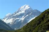
new zealand - New Zealand is a country in the southwestern Pacific Ocean comprising two large islands (the North Island and the South Island) and numerous smaller islands, most notably Stewart Island and the Chatham Islands. In Maori, New Zealand is also known as Aotearoa, which is usually translated into English as the Land of the Long White Cloud. The Realm of New Zealand also includes the Cook Islands and Niue, which are self-governing, but in free association; Tokelau; and the Ross Dependency (New Zealand's territorial claim in Antarctica). New Zealand, Hawaii and Easter Island form what is known by anthropologists as the Polynesian Triangle. New Zealand is notable for its geographic isolation, being separated from Australia to the northwest by the Tasman Sea, some 2000 kilometres (1250 miles) across. Its closest neighbours to the north are New Caledonia, Fiji, and Tonga. The population is mostly of European descent, with the indigenous Maori being the largest minority. Non-Maori Polynesian and Asian people are also significant minorities, especially in the cities. Elizabeth II, as the Queen of New Zealand, is the Head of State and is represented, in her absence, by a non-partisan Governor-General; the Queen 'reigns but does not rule', so she has no real political influence. Political power is held by the democratically-elected Parliament of New Zealand under the leadership of the Prime Minister who is the Head of Government. New Zealand Geography New Zealand comprises two main islands (called the North and South Islands in English, Te-Ika-a-Maui and Te Wai Pounamu in Maori) and a number of smaller islands, located near the center of the water hemisphere. The total land area, 268,680 square kilometres (103,738 sq miles), is a little less than that of Italy and Japan, and a little more than the United Kingdom. The country extends more than 1600 kilometres (1000 miles) along its main, north-north-east axis, with approximately 15,134 km of coastline. The most significant of the smaller inhabited islands include Stewart Island/Rakiura; Waiheke Island, in Auckland's Hauraki Gulf; Great Barrier Island, east of the Hauraki Gulf; and the Chatham Islands, named Rekohu by Moriori. The country has extensive marine resources, with the seventh-largest Exclusive Economic Zone in the world, covering over four million square kilometres (1.5 million sq mi), more than 15 times its land area. The South Island is the largest land mass, and is divided along its length by the Southern Alps, the highest peak of which is Aoraki/Mount Cook at 3754 metres (12,316 ft). There are 18 peaks of more than 3000 metres (9800 ft) in the South Island. The North Island is less mountainous than the South, but is marked by volcanism. The tallest North Island mountain, Mount Ruapehu (2797 m / 9176 ft), is an active cone volcano. The dramatic and varied landscape of New Zealand has made it a popular location for the production of television programmes and films, including the Lord of the Rings trilogy, and the Last Samurai. The climate throughout the country is mild, mostly cool temperate to warm temperate, with temperatures rarely falling below 0°C (32°F) or rising above 30°C (86°F). Conditions vary from wet and cold on the West Coast of the South Island to dry and continental in the Mackenzie Basin of inland Canterbury and almost subtropical in Northland. Of the main cities, Christchurch is the driest, receiving only some 640 mm (25 in) of rain per year. Auckland, the wettest, receives almost twice that amount. New Zealand is part of Zealandia, a continent that is 93% submerged. Zealandia is almost half the size of Australia and is unusually long and narrow. About 25 million years ago, a shift in plate tectonic movements began to pull Zealandia apart forcefully. The submerged parts of Zealandia are the Lord Howe Rise, Challenger Plateau, Campbell Plateau, Norfolk Ridge and the Chatham Rise. New Zealand Flora and Fauna Because of its long isolation from the rest of the world and its island biogeography, New Zealand has extraordinary flora and fauna. About 80% of the New Zealand flora occurs only in New Zealand, including more than 40 endemic genera. The two main types of forest have been dominated by podocarps including the giant kauri and southern beech. The remaining vegetation types in New Zealand are grasslands of tussock and other grasses, usually in sub-alpine areas, and the low shrublands between grasslands and forests. Until the arrival of humans, 80% of the land was forested. Until 2006, it was thought, barring three species of bat (one now extinct), there were no non-marine native mammals. However, in 2006, scientists discovered bones that belonged to a long-extinct, unique, mouse-sized land animal in the Otago region of the South Island. New Zealand's forests were inhabited by a diverse range of birds including the flightless moa (now extinct), and the kiwi, kakapo, and takahe, all endangered by human actions. Unique birds capable of flight include the Haast's eagle, which was the world's largest bird of prey (now extinct), and the large kaka and kea parrots. Reptiles present in New Zealand include skinks, geckos and tuatara. There are four endemic species of primitive frogs. There are no snakes and there is only one venomous spider, the katipo, which is rare and restricted to coastal regions. However, there are many endemic species of insects, including the weta, one species of which may grow as large as a house mouse and is the heaviest insect in the world. New Zealand has led the world in clearing offshore islands of introduced mammalian pests and reintroducing rare native species to ensure their survival. A more recent development is the mainland ecological island. History of New Zealand New Zealand is one of the most recently settled major land masses. Polynesian settlers arrived in their waka some time between the 11th century and the 13th century to establish the indigenous Maori culture. New Zealand's Maori name, Aotearoa, is usually translated as 'Land of the long white cloud', reputedly referring to the cloud the explorers saw on the horizon as they approached. Settlement of the Chatham Islands to the east of the mainland produced the Moriori people; linguistic evidence, in particular the innovations uniquely shared by the Moriori and Maori languages, indicates that they moved there from New Zealand. Most of New Zealand was divided into tribal territories called rohe, resources within which were controlled by hapu ('subtribes'). Maori adapted their tropically-based culture to eating the local marine resources, flora and fauna for food. They also hunted the giant flightless moa (which soon became extinct). They showed great ingenuity in adapting their tropical agricultural technology to a temperate climate, successfully cultivating taro, gourds, kumara (sweet potato), and other plants which they introduced from Polynesia; it is thought that kumara were grown as far south as Banks Peninsula in the middle of the South Island. While it was fairly easy to grow these crops in the north, these warm-climate crops were impractical in the south of the South Island. However, inter-regional trade and the exploitation of the few food plants of the local flora made up the difference. They also introduced other plants such as the paper mulberry or 'aute', used to make barkcloth for kites and for personal adornment. The first Europeans known to have reached New Zealand were led by Abel Janszoon Tasman, who sailed up the west coasts of the South and North Islands in 1642. He named it Staten Landt, believing it to be part of the land Jacob Le Maire had seen in 1616 off the coast of Chile. Staten Landt appeared on Tasman's first maps of New Zealand, but this was changed by Dutch cartographers to Nova Zeelandia, after the Dutch province of Zeeland, some time after Hendrik Brouwer proved the supposedly South American land to be an island in 1643. The Latin Nova Zeelandia became Nieuw Zeeland in Dutch. Captain James Cook subsequently called the archipelago New Zealand (a slight corruption, as Zealand is not an alternative spelling of Zeeland, a province in the Netherlands, but of Sjælland, the island in Denmark that includes Copenhagen), although the Maori names he recorded for the North and South Islands (as Aehei No Mouwe and Tovy Poenammu respectively) were rejected, and the main three islands became known as North, Middle and South, with the Middle Island being later called the South Island, and the earlier South Island becoming Stewart Island. Cook began extensive surveys of the islands in 1769, leading to European whaling expeditions and eventually significant European colonisation. From as early as the 1780s, Maori had encounters with European sealers and whalers. Acquisition of muskets by those iwi in close contact with European visitors destabilised the existing balance of power between Maori tribes and there was a temporary but intense period of bloody inter-tribal warfare, known as the Musket Wars, which ceased only when all iwi were so armed. Concerned about the exploitation of Maori by Europeans, the British Colonial Office appointed James Busby as British Resident to New Zealand in 1832. In 1834, Busby convened the United Tribes of New Zealand to select a flag and declare their independence, which led to the Declaration of the Independence of New Zealand. This declaration did not allay the fears of the Church Missionary Society, who continued lobbying for British annexation. Increasing French interest in the region led the British to annex New Zealand by Royal Proclamation in January 1840. To legitimise the British annexation, Lieutenant Governor William Hobson had been dispatched in 1839; he hurriedly negotiated the Treaty of Waitangi with northern iwi on his arrival. The Treaty was signed in February, and in recent years it has come to be seen as the founding docume